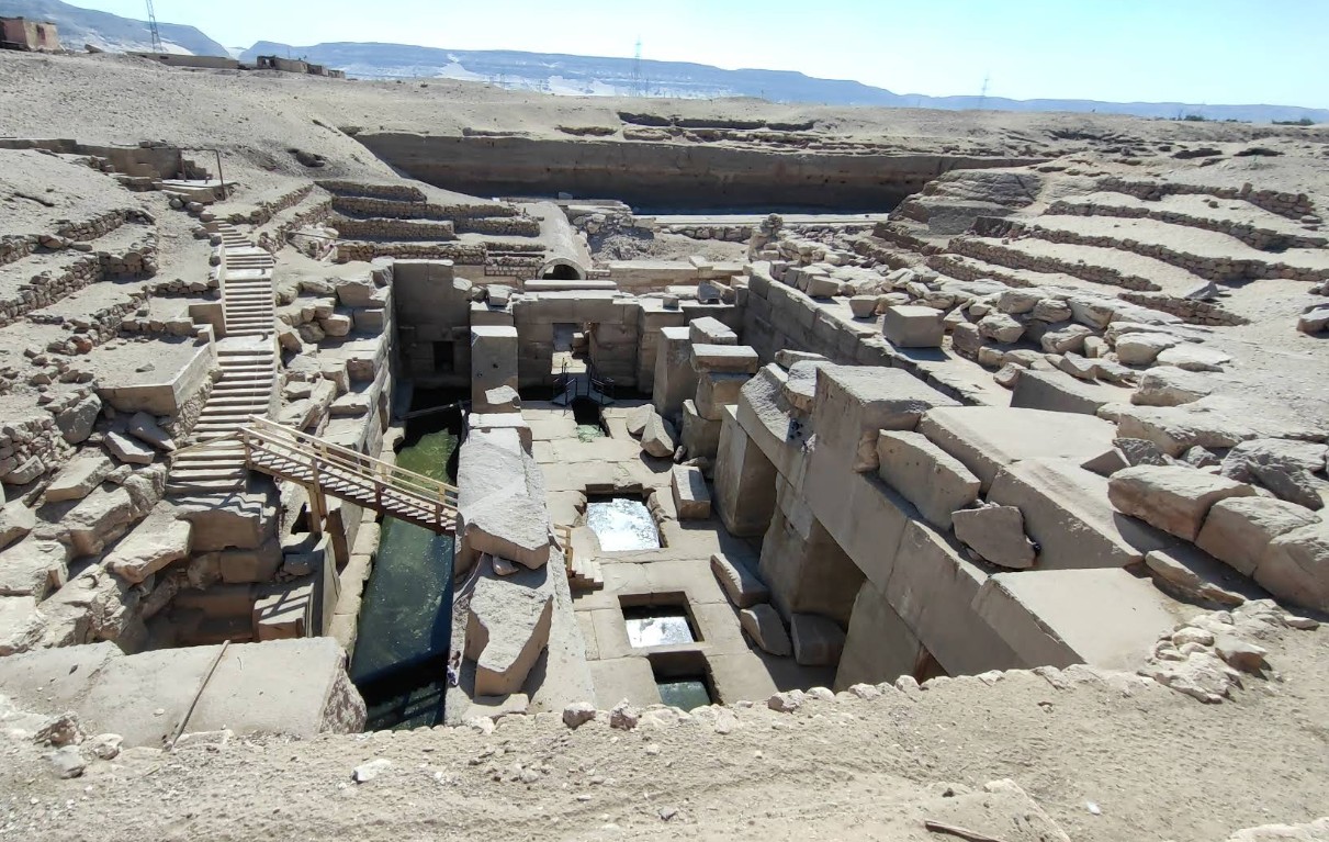
To the rear of the Temple of Seti I at Abydos, there exists a fascinating subterranean pre-dynastic megalithic structure called the Osireion. It consists of a central ‘island’ surrounded on all four sides by a water channel that is connected to some underground water source. On both of the long sides of the island, a row of five cyclopian stone pillars of more than two meters wide were placed, on top of which the remains of large stone slabs are lying. On the outer sides of the channel, ‘niches’ exist that once would have doors (indicated by core drillings in the top lintels). It is important to note that the entire structure, its massive pillars, walls, and roof slabs, is made from red sandstone. This is identified as Nubian Sandstone, from a geological formation widespread in southern Egypt and Sudan. Only a minor amount of granodiorite is used for door sills, lintels, and some interior paving blocks. All of the inscriptions on the walls date from later times and were not there originally.

The above plan shows the high degree of symmetry of the construction, both in left-right and in top-bottom direction. The two transverse chambers are just window-less spaces with a vaulted ceiling.

Besides the sense of awe for these structures, many questions also arise:
- When was the Osireion built and for what purpose? In my opinion the later Dynastic Egyptian civilization incorporated the much older megalithic sites with much respect into their culture. How old? Can the carving of a sandstone block be dated? Some try to date on the basis of weathering and erosion, however, for a very long time, the Osireion was buried under a layer of sand. And its purpose…we will try to find out!
- Why is the structure built subterranean? Maybe to be closer to something below?
- What was the significance of the island canal architecture? Water seems to be a prominent factor here.
- Why was only Nubian Sandstone used to build it? I’ll come back to that later in this post.
- Why are the pillar and roof blocks so excessively large? Should it be protected against outside forces?
- What caused the massive destruction and what forces might have broken the mega-blocks? An incredible force.
We will ponder more on these questions, but first we dive into the rock formations underground.
Geology and hydrology of the area


The above image depicts on the left (a) a heavily-simplified geological map of the eastern part of Egypt. It comprises the area where the Nile flows and where sites like the Giza Plateau and Abydos with its Osireion are located. The SW-NE cross-section (A-A’) on the right (b) runs approximately 100 km north of The Osireion. In the context of this post, we will compare the rock stratification at the Osireion with that at the Giza Plateau. Do these two locations have a link? … Maybe. The difference is that the pyramids at Giza are built right on top of a thick limestone layer (the Mokattam Limestone Formation), while the Osireion is carved down to a certain depth into the rocks (the Dakhla Shale Formation).
At the Giza Plateau there is the following sequence (from top to bottom):
- Surface Layer. Weathered limestone and marl debris.
- Mokattam Formation (Eocene). The primary building stone for the pyramid cores. It’s a thick, massive, fossiliferous limestone, forming the visible cliffs and the plateau itself. [Dark blue in the map]
- Esna Shale (Paleocene). A thin, greenish-grey impermeable shale layer. It acts as a natural water barrier. [Grey in the map]
- Maadi Formation (Upper Cretaceous). Consists of shales, marls, and some limestones. This unit is softer and less competent. [Light blue in the map]
- Nubian Sandstone (Early Cretaceous – Jurassic). A hard, porous, quartz-rich sandstone. [Yellow in the map]
- Precambrian basement. Contains schists and the Aswan granite pluton, a very high-quality red granite intensively used by the ancient builders. [Purple in the map]
At the Osireion, however, the Mokattam limestone and the Esna shale have been completely eroded off, exposing the ancient Dakhla Shale (in age and composition comparable to the Maadi Formation at Giza). This leads to the following sequence at the Osireion (from top to bottom):
- Surface Layer. Alluvial deposits consisting of quaternary sands and gravels.
- Sudr Chalk Formation (Cretaceous). [Light blue in the map]
- Dakhla Shale Formation (Cretaceous). This is Osireion foundation. [Light blue in the map]
- Nubian Sandstone (Early Cretaceous – Jurassic). [Yellow in the map]
- Precambrian basement. [Purple in the map]
Focussing on the Nubian Sandstone with which the Osireion has been built, it is a hard, cross-bedded, quartz-rich sandstone, ranging in color from white and yellow to deep red and brown (due to iron oxide cement). In hydrological terms it is a major regional aquifer (the Nubian Sandstone Aquifer System), one of the largest fossil water reservoirs in the world. Its porosity and permeability allow it to hold and transmit vast amounts of groundwater. Below the Osirion, the Nubian Sandstone sequence is generally 200 to 300 meters thick before hitting the underlying basement granite and schist. Based on regional dip and known thicknesses of overlying layers, the top of the Nubian Sandstone Group in the Abydos area is estimated as several hundred meters below the surface. In comparison, beneath Cairo and the Giza Plateau, the top of the Nubian Sandstone aquifer is estimated to begin at a depth of 500 to 700 meters below the surface, and it may be hundreds to thousands of meters in thickness.
At Abydos and its Osireion, the Dakhla Shale acts as a perfect regional seal, that traps the water from the underlying Nubian Sandstone. The thick Nubian Sandstone layer has some quite interesting properties concerning the water it contains. You can think of it as ‘fossil water’ with an maximum age of more than a million years. Because of its depth and due to the geothermal gradient, it has been geothermally warmed to an estimated temperature of 35°C or higher. Its composition is very fresh, with a unique isotopic fingerprint with low ratios of Deuterium and Oxygen-18.
Quarrying the building blocks
The builders of the Osirion almost certainly sourced their massive Nubian Sandstone blocks from the exposed cliffs at Gebel el-Silsila, located about 200 km in a straight line south of Abydos. Obviously, they were specifically interested in the high-quality sandstone, otherwise they could have picked the red granite from Aswan, which is located at 276 km. The choice of building material makes the Osireion stand out as a structure that pre-dates Dynastic Egypt in the New Kingdom, as the Seti I Temple at Abydos is constructed from high-quality white limestone, which was likely quarried from the much closer Thebes Formation outcrops located west of Abydos.
Possible ancient engineering
We can conclude that this construction is evidently related to water. Can you imagine that its water channels were filled with alluvial water or from the Nile itself, when there is a very large supply of special water available in a sandstone formation down below. Obviously, the ancient builders were aware of this and let’s start brainstorming here: What if they drilled several hundred meters down into the Nubian Sandstone to access this water…why not if they were capable of transporting the 50-ton pillars over 200 km. The upward pressure in the sandstone would then drive the hot and fresh water out of the rock and into the water channels of the Osireion.
The idea of deep shafts under megalithic structures is not far-fetched (definitely not in this blog…). Recent measurements with Synthetic Aperture Radar Doppler Tomography at the Giza Plateau by the Italian group of Filippo Biondi might indicate the presence of shafts running several hundred meters deep, ending in some kind of chamber. Of course these are preliminary results, but if indeed present, could these shafts at Giza also deliberately end in the Nubian Sandstone aquifier?
We can now further speculate that the ancient engineers used the hot water as an energy source, like we today use geothermal energy extracted from the Earth’s crust to generate energy and to heat our homes. Besides that, the special properties of this water may also have been useful for healthcare purposes or whatever these people were knowledgeable and capable of. They may have deliberately used the same building material from which the water is released, namely the Nubian Sandstone, to keep the special properties of the water intact during its transport and storage. The water in the channels would remain in equilibrium with that in the porous sandstone pillars, which could be one of the reasons for their massiveness.
Contemplating it all
Water is an intriguing substance. It is essential for all living organisms and its role obviously goes beyond just being a solvent. For instance, water molecules can form organized structures that hold information, in fact, ‘memorize’ substances or other information it has come into contact with. If my speculative thoughts are grounded, meaning that the water in the Osireion came from a deep and very old rock layer, the question is: how was this water applied. To my knowledge, in present-day Egypt there have never been any drilling attempts to reach the Nubian Sandstone … What do you think, would drilling have occurred if oil had been trapped in these rocks instead of clean water?
Leave a Reply